|
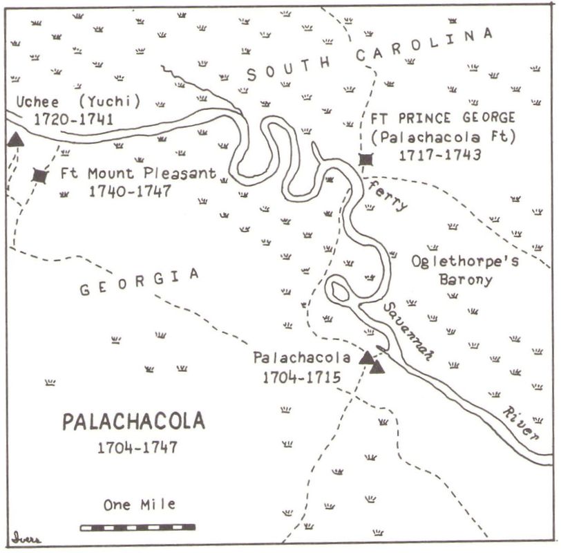
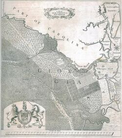
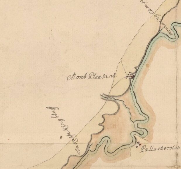
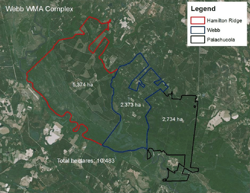
What's in a name? Sometimes it can be confusing. The Savannah River is also historically known as the Westobou and the Isundiga. Beneath the waters of Lake Hartwell the Savannah River is formed by the joining of the Tugaloo and Seneca Rivers. Another example of confusing naming, we have Tobler's Creek, which joins the Savannah River in Burke County. It is named for Colonial South Carolina trader, and rum-runner, William Tobler. Yet it is also known as Jobley's Creek. That corruption in the name began quite early, sometime after the Revolutionary War.  Another interesting place named along the course of the river is Pallachocolas, or Palachucola, or Palachocolas, or Palachacola, or Palachuckaly, or Parachucla, or Parachuchio, or Stoke's Bluff Landing. The two oldest versions of the name are Pallachocolas and Palachuckaly. Stoke's Bluff is the modern name for the riverside portion of this area. Another modern version is Palachucola, which is used for a South Carolina Wildlife Management Area. This is a site along the Savannah River between Clyo, GA, and Garnett, SC. In colonial times it began as a Native American settlement, then became a trading post, and then a fort/outpost for a Ranger force of South Carolina. A trading path started from that site on the Carolina side of the Savannah River. It was known as the Pallachocolas Old Trading Path. The path went westwards and crossed the nearby Ogeechee River in Jenkins County, GA. Georgia's General James Oglethorpe established a ferry between Pallachocolas and nearby Tuckasee King Landing on the other side of the river. This ferry site was abandoned in favor of the nearby "Two Sisters" ferry site. Stoke's Bluff features a public landing with a boat ramp allowing access to the river. It's reached by turning off SC State Route 119 and following Stokes Bluff Road to the landing. From the river and ranging further north along SC 119 (closer to Garnett) is the Palachucola Wildlife Management Area, which surrounds Stoke's Bluff on three sides. This can be thought of as the modern version of the original Pallachocolas, now adjacent to the Savannah River Nature Trail and James W. Webb Wildlife Center. Nearby the Webb Center is the Hamilton Ridge Wildlife Management Area, which runs northwestwards along the SC bank of the Savannah River. These three South Carolina reserves combined form 10,481 hectares of public lands, with plenty of public access. Pallachocolas is a historically interesting place, being partially made up of the 1731 "Oglethorpe Barony" created by General Oglethorpe. This appears to have been something akin to a medieval landholding in Colonial South Carolina, along the course of the Savannah River. This was just before Oglethorpe becoming the first Governor of the Georgia Colony in 1733. While Georgia forbade slavery, General Oglethorpe operated his South Carolina "Barony" (really just a plantation) with slave labor. On the early border between South Carolina and Georgia, the site of Pallachocolas was one of the few landmarks found along the course of the Savannah River.  Accompanying this blog entry are two maps from 1735 and 1752, and a modern map interpreting how the area appeared during the first half of the 18th century. The modern map places "Palachacola" on the bluff above Tuckasee King Landing in Georgia, rather than in South Carolina. Yet the Palachocola Fort is in SC alongside General Oglethorpe's 'Barony.' The importance of the Pallachocolas area declined as the local ferry crossing of the river moved to the site of Two Sisters Ferry, which featured high ground to either side of the river. Higher ground allowed the roads approaching the river to remain more passable between the two colonies, and later the states, throughout the seasons. The competing ferry brought about the fading of the importance of Pallachocolas.
Here's a link to a Lowcountry account of modern Palachucola. Locallife - Hilton Head Island & Bluffton Secret spot off the beaten path: Palachucola https://www.locallifesc.com/secret-spot-off-the-beaten-path-palachucola/ Email Dale: [email protected]
5 Comments
Bill Bibeault
1/29/2023 06:09:18 am
I am studying the Savannah River and like to talk to you about her.
Reply
carole
2/5/2023 04:46:26 pm
excellent compilation Dale and thank you as always.
Reply
Bill Bibeault
2/21/2023 05:12:23 am
Carole
Reply
7/11/2023 05:46:50 pm
Check out my website and book. I am also writing a new book and interested in some of the old landings in Burke County in particular but also the S.C. side of the river. Anyone know anything about Rattlesnake Camp, near the Steel Creek Landing site?
Gary Wain
9/26/2023 03:26:59 pm
Hi, Leave a Reply. |
Details
Dale ReddickAs the researcher for Savannah Riverkeeper, Dale Reddick knows a lot about the Savannah River. While his work mostly focuses on current issues throughout the basin, his knowledge expanses the centuries the river's current has rushed to the Atlantic Ocean. Dive "Deep in the River" as Dale's post on historic spots along the Savannah River. ArchivesCategories |
Savannah Riverkeeper, Inc. • Augusta, GA • Allendale, SC • Savannah, GA
P.O. Box 60 Augusta, GA 30903 USA • [email protected]
Toll Free 844-263-1415 • Office 706-826-8991 • Fax 706-826-8995
Savannah or Allendale: 912-454-8048
EIN # 58-2630660
P.O. Box 60 Augusta, GA 30903 USA • [email protected]
Toll Free 844-263-1415 • Office 706-826-8991 • Fax 706-826-8995
Savannah or Allendale: 912-454-8048
EIN # 58-2630660


 RSS Feed